


Geospatial Information Sciences
Geospatial Information Sciences
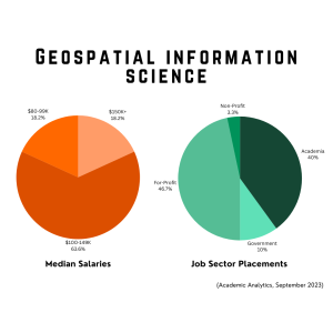
Our undergraduate and graduate degrees and certificate programs in Geospatial Information Sciences prepare students to work in a fast-growing field that involves using technology to collect, store, manage and analyze geographical data. Students gain skills using technologies including geographic information systems (GIS), global positioning system (GPS) and satellite-based remote sensing.
The Geospatial Information Sciences program ranked No. 1 in the nation for GIScience/Computation and Spatial Analysis/Statistics by Geographical Perspectives. The National Geospatial-Intelligence Agency and the U.S. Geological Survey designated the program a Center of Academic Excellence, the only one in Texas and one of 17 nationwide, and Esri named it one of its Innovation Programs. Our faculty includes leading experts in the field and pioneering researchers in Geospatial Information Sciences.
Computational and Geospatial Science
Our Bachelor of Science in Computational and Geospatial Science, offered in collaboration with the Erik Jonsson School of Engineering and Computer Science, prepares students to address complex, location-based challenges across diverse fields such as environmental management, energy planning, national security, disaster response, and more. The program explores the power of geospatial data and its applications on the Earth’s surface, from widely used tools like web mapping services to mission-critical operations in government and industry.
Students gain hands-on experience with cutting-edge technologies including satellite imagery, drones and mobile data collection. They develop expertise in Geographic Information Systems (GIS), remote sensing, and spatial data science, while building strong programming and computational skills.
Graduates are uniquely positioned to lead in a rapidly evolving world where understanding and analyzing spatial relationships is essential for solving global problems.
Complete your online application
Explore funding opportunities
See how UT Dallas is built different.

Earn Your MS in GIS — 100% Online
You can now earn your MS in GIS entirely online through our comprehensive Geospatial Information Sciences program. With world-class faculty and a curriculum grounded in practical, analytical, and theoretical expertise, students develop the skills needed to tackle complex spatial problems. This flexible format allows you to advance your education and career on your schedule.
List of Courses Available Online
- GISC 6301 GIS Data Analysis Fundamentals
- GISC 6317 (EPPS 6317) Python Programming for Social Science
- GISC 6321 Spatial Data Science
- GISC 6325 (GEOS 5325) Remote Sensing Fundamentals
- GISC 6331 (CRIM 6332) GIS Applications in Criminology
- GISC 6336 (EPPS 6336) Fundamentals of Sustainability
- GISC 6338 (EPPS 6338) Hazard and Disaster Management
- GISC 6363 Internet Mapping and Information Processing
- GISC 6381 (GEOS 6381) Geographic Information Systems Fundamentals
- GISC 6382 (GEOS 6383) Applied Geographic Information Systems
- GISC 6384 (GEOS 6384) Advanced Geographic Information Systems
- GISC 6387 (GEOS 6387) Geospatial Sciences Workshop
- GISC 6389 Geospatial Information Sciences Master’s Research
- GISC 7365 (GEOS 5326) Advanced Remote Sensing
With the courses listed above, graduate certificates in GIS, RS, and GeoINT can be also completed 100% online.
PhD GIS Job Market Candidates
Partnership & Sponsored Award

In a strategic partnership between UT Dallas and Pioneer Natural Resources, GIS Pioneer Scholarships have been created through Pioneer’s generous donation. These scholarships bolster our program with career-focused instruction, support advanced research, and aim to expand undergraduate participation while encouraging further studies at UT Dallas.
Our GIS program is also a designed Esri Innovation Program (EIP). Our students have the opportunity to win the Esri Innovative Program Students of the Year Award, which comes with a $500 prize and other honors.
Undergrad Fast Facts

Master’s Fast Fact


UTD PhD Alumni Insights
Learn More
More information on Master of Science in GIS
More information on Bachelor of Science Degrees
Geospatial Information Sciences
- BS in Geospatial Information Sciences
- BS in Geospatial Information Sciences Degree Plan (pdf)
- Minor in Geospatial Information Sciences
- Minor in Geography
Computational and Geospatial Science